
Pinhoti Trail Markings & MapsWell-marked wilderness from Georgia to Alabama
Planning & Preparation

Explore the 351-mile Pinhoti Trail section by section. Discover mileage breakdowns, resupply towns, elevation details, and essential planning info for Alabama and Georgia’s premier long-distance hiking trail.

This website uses affiliate links which may earn a commission at no additional cost to you. As an Amazon Associate I earn from qualifying purchases.
Quick Trail Facts
Difficulty: Intermediate
Distance: 351 mi
Elevation Gain: 43,589 ft
Flagg Mountain – Benton MacKaye Trail
Average Time: 2-3 Weeks
Permit Required?: false
The Pinhoti Trail stretches approximately 351 miles through Alabama and Georgia, beginning at Flagg Mountain near Weogufka, Alabama (elevation 1,000+ feet) and ending where it joins the Benton MacKaye Trail in northern Georgia. With approximately 43,589 feet of total elevation gain, this trail offers a substantial challenge while remaining more approachable than some of its longer cousins.
The trail consists of roughly 177 miles in Alabama and 174 miles in Georgia (exact mileage varies slightly depending on recent reroutes and trail improvements). The highest point is Buddy Cove Gap at 3,164 feet near the Cohutta Wilderness, and the lowest point is near Weogufka Creek at 545 feet.
The Alabama portion traverses the Talladega National Forest, passing through the Cheaha Wilderness and Dugger Mountain Wilderness areas. Alabama currently has approximately 161 miles of woods trail and 16 miles of road walk, with nine three-sided shelters along the trail.
Key Alabama Features:
Southern Sections (Miles 0-30): Road walks occur primarily in Sections 1 and 2 starting from Flagg Mountain. This includes passages through the town of Weogufka and past Terrapin Highlands. Ongoing trail improvements aim to reduce road walking.
Central & Northern Sections (Miles 30-177): These sections wind through the heart of the Talladega National Forest featuring 14 rock gardens requiring careful navigation, numerous water crossings, and the infamous “Stairway to Heaven,” a half-mile climb gaining 560 feet where hand-over-hand scrambling is sometimes necessary.
Major Alabama Resupply Points:
Water Considerations: Several 10-15 mile waterless sections exist throughout Alabama; carry extra capacity and plan carefully, especially during dry seasons.
The Georgia guide covers 169.2 miles of trail, though with recent additions like the Chief Vann House section, the total has grown to approximately 174 miles. Georgia’s portion travels through the Chattahoochee National Forest with one shelter located shortly after crossing the state line from Alabama.
Critical Planning Note: Georgia has approximately 135 miles of woods trail and 43 miles of road walk, significantly more pavement than Alabama.
Major Georgia Road Walks:
Many thru-hikers choose to hitchhike around these lengthy road sections due to safety concerns, limited camping options on private property, and the physical toll of walking pavement.
Key Georgia Resupply Points:
Shelter System: Approximately 75 established overnight sites including campsites with fire rings and AT-style shelters. First-come, first-served basis. Alabama has nine shelters; Georgia has one.
Camping Options:
Parking Warning: Multiple hikers have reported car break-ins at trailheads. Consider parking at the Pinhoti Outdoor Center, Mulberry Gap, or other monitored locations for longer trips.
Typical Timeline: Most hikers complete the trail in 2-3 weeks (14-21 days), though some hikers average 10-15 miles per day and take about a month.
Daily Mileage: Those hiking in late spring, summer, or early fall can cover 15-20 miles per day due to gentler inclines and smoother trail tread. Winter and early spring: 10-15 miles per day is more comfortable due to weather and shorter daylight hours.
Best Hiking Seasons: October through March offers cooler temperatures and fewer insects. Late spring through early fall brings heat, humidity, and aggressive bugs.
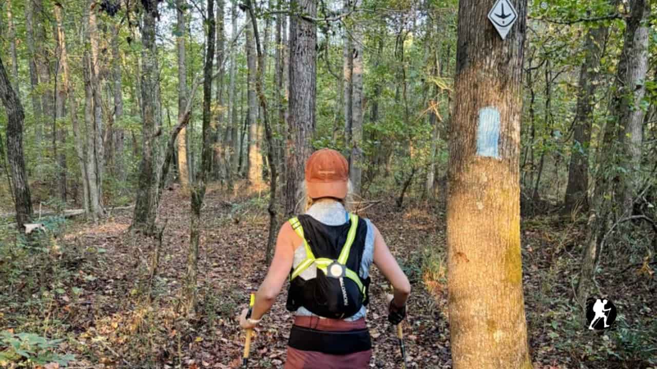
Navigation: The trail uses light blue or white blazes (2×6 inches). The Pinhoti Trail is well-signed compared to some other thru-hikes. Navigation apps like FarOut provide updated waypoints, water sources, and resupply information.
Permits: None required.
Resupply Strategy: No mail drops necessary, towns and convenience stores are accessible throughout. Shuttle services available through Pinhoti Outdoor Center. Plan for longer food carries during Georgia road walk sections where camping is limited.
Water: Always filter or treat water sources. Carry at least 2 quarts; seasonal springs dry quickly after rain.
One of the most challenging aspects is the two long road walking sections, 27 miles north of Dalton and about 30 miles north of Cave Springs. Due to private property, camping is extremely limited along these paved stretches. Many hikers choose to hitchhike around these sections or plan very long days to reach towns.
The Pinhoti offers an excellent training ground for aspiring long-distance hikers while providing a rewarding experience for those seeking a shorter yet challenging Southern Appalachian adventure. At 351 miles, this trail is more approachable for the average person than other longer thru-hikes.
Planning & Preparation
Planning & Preparation
Planning & Preparation

Planning & Preparation