
Ocean to Lake Trail | Lake Okeechobee to Atlantic Ocean Adventure
Plan your Ocean to Lake Trail thru-hike with our detailed section guide. Covers all 61 miles from Hobe Sound Beach to Lake Okeechobee, including resupply points, campsites, and essential logistics for this unique Florida backpacking adventure.

This website uses affiliate links which may earn a commission at no additional cost to you. As an Amazon Associate I earn from qualifying purchases.
Quick Trail Facts
Difficulty: Easy
Distance: 61 mi
Elevation Gain: 350 ft
Lake Okeechobee – Hobe Sound Beach
Average Time: 3-6 Days
Permit Required?: false
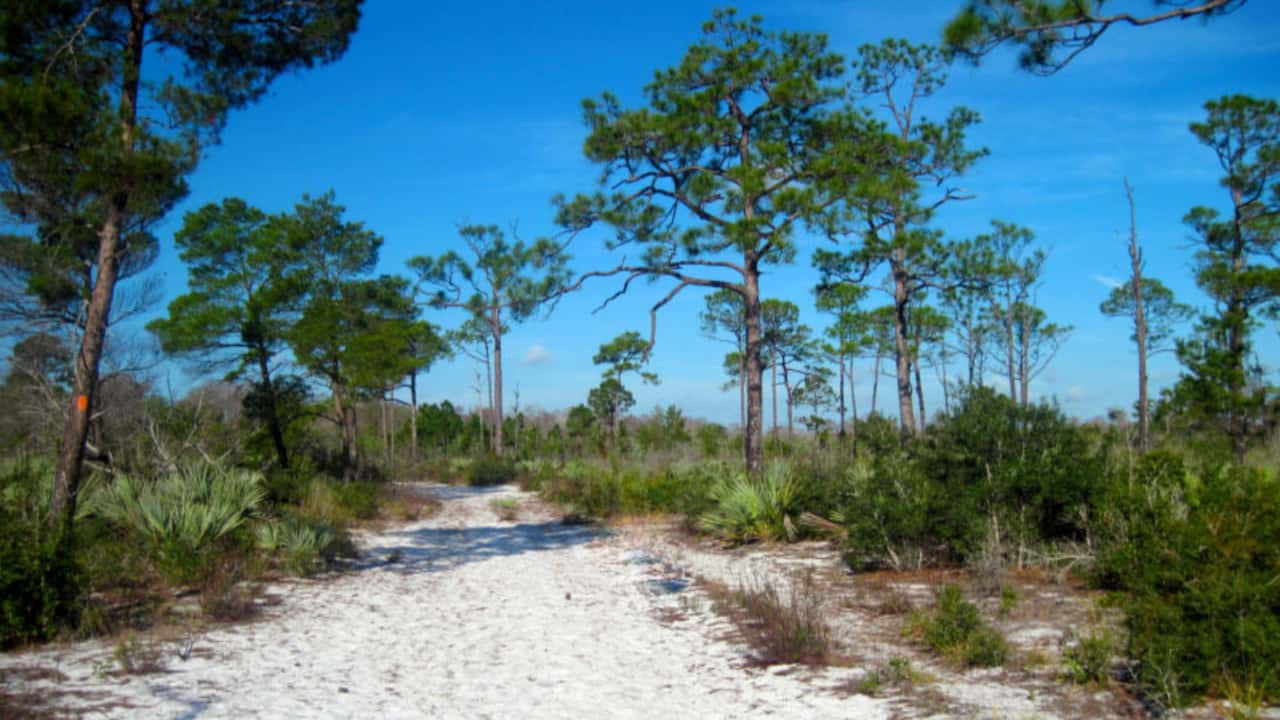
The Ocean to Lake Hiking Trail (OTL) spans approximately 61-63 miles from Hobe Sound Beach on the Atlantic Ocean westward to Lake Okeechobee, where it connects with the Lake Okeechobee Scenic Trail (LOST). As a secondary trail of the Florida Trail System, the OTL showcases South Florida’s incredible biodiversity through constantly changing ecosystems, from ancient sand dunes and coastal scrub to cypress swamps, wet prairies, and pine flatwoods.
Total Elevation Gain: Approximately 160-350 feet (minimal by most standards, but Florida roots and water features add technical challenge)
Most thru-hikers complete this trail in 3-6 days, with the majority opting for a 4-5 day itinerary. The trail’s relatively short distance makes it an excellent weekend warrior challenge or first-time backpacking trip, while its unique water crossings and ecological diversity provide enough adventure to satisfy experienced hikers.
When to Hike the OTL
The ideal hiking season is late November through early March, with December and January offering the best conditions. Winter temperatures range from 40°F at night to 70-80°F during the day, with occasional dips to freezing.
Avoid summer and early fall due to intense heat, humidity, aggressive insects, and significantly higher water levels. The trail can become impassable during Florida’s rainy season. Late March through October is not recommended for thru-hiking.
OTL Sections West to East
Section 1: Lake Okeechobee to DuPuis Management Area
Miles 0-10 (from western terminus)
The trail begins at the North Everglades Natural Area (NENA) trailhead near Port Mayaca, approximately 2.5 miles south of the town. The first 3.5 miles follow a canal grade and unpaved road offering easy walking but limited shade. This section provides good views across open landscape before entering DuPuis Management Area.
Key Features:
- Mesic flatwoods with scrub palms
- Relatively dry walking initially
- Loop 4 Campsite (mile 9): Features a working pitcher pump (sulfurous but reliable) and dry pine needle camping, a welcome relief after the wetter sections to the east
Parking/Access: Parking at NENA trailhead is exposed and not recommended for multi-day trips. Alternative start: Park at the Governor’s House pavilion inside DuPuis for safer parking and connect via western loop trails.
Section 2: DuPuis to Corbett Wildlife Management Area
Miles 10-31 (approximately)
This section transitions into the trail’s wettest and wildest terrain. Water levels increase significantly as you approach and enter Corbett WMA, which contains the most extensive cypress dome swamps, strand swamps, and wet prairies on the entire trail.
Key Features:
- Expect ankle to knee-deep water for extended stretches
- Beautiful shallow lakes and winding singletrack through cypress domes
- Powerline Camp (mile ~21): No permit required
- Corbett Everglades Youth Camp (mile ~31): Marks the halfway point; usually reserved for groups
- Bowman Island Camp (mile ~25): Unique island campsite reached by wading ~30 yards through water; jungle clearing in the middle
- Little Gopher Campsite (mile ~31): Excellent site with benches, fire pit, and proximity to two small lakes and Big Gopher Canal (alligator habitat)
Permits/Access: Corbett WMA requires an entrance fee. Some sections may close for hunting seasons or prescribed burns, check with land managers before your trip.
Parking: South entrance to Corbett on Pratt Whitney Road offers parking, though safety for multi-day trips varies.
Water: Despite walking through water, designated sources include pitcher pumps and canals. The water you walk through is often cleaner than standing water sources.
Section 3: Corbett to Riverbend Park
Miles 31-46 (approximately)
The trail continues through Palm Beach County Natural Areas with mixed hydric and mesic flatwoods. Water levels typically begin decreasing in this section, though conditions vary by season.
Key Features:
- Gradual drying out compared to Corbett section
- Transition through palmetto and oak hammocks
- Big Marsh Campsite (mile ~39): No ground fires permitted; water nearby
- Riverbend Park (mile ~46): Southern entrance/exit point with parking
Resupply: The trail crosses Indiantown Road near Riverbend Park (mile 46.5 from the west, mile 15 from the east), this is the primary resupply point. On-trail access to a Sunoco gas station and restaurants. Full grocery: Walk 1.3 miles west on Indiantown Road to Sierra Square shopping plaza with grocery store and additional restaurants.
Parking: Riverbend Park offers parking for day hikes or section hiking.
Section 4: Riverbend to Jonathan Dickinson State Park
Miles 46-56 (approximately)
This section features a dramatic ecosystem change as you leave the wetlands and approach the coast. The trail passes under the Florida Turnpike and enters Jonathan Dickinson State Park, Florida’s first state park.
Key Features:
- Cross Kitching Creek on pole bridge
- Dense forest transitions to tall pine forest
- Scrub Jay Campsite (mile ~57): $5 camping permit required; call 772-546-2271
- Kitchen Creek Campsite (mile ~55): $5 permit required; no permit needed at this specific site per some sources (verify current requirements)
- Lucky Tract Campsite (available in this section)
Special Feature: Jonathan Dickinson protects habitat for the endangered Florida scrub jay, watch for these unique birds in the scrub habitat.
Parking/Access: Multiple access points within Jonathan Dickinson State Park. Main parking requires park entrance fee at front gate or kiosk. Highway US 1 provides access at the northeast corner of the park.
Section 5: Jonathan Dickinson Sand Dunes to Hobe Sound Beach
Miles 56-61 (eastern terminus)
The trail’s grand finale showcases one of its most distinctive features: rolling white sand dunes unique to Florida hiking. This ancient dune ecosystem with scrub oak and sand pine feels otherworldly.
Key Features:
- Rolling sand dunes: Soft, deep sand makes for challenging but spectacular walking
- Coastal sand pine scrub habitat
- Abrupt transition from dunes to civilization
- Road walk: 2-mile stretch through historic Hobe Sound neighborhood
- “Tunnel of Trees”: Beautiful canopy of banyan trees on both sides of the road
- Hobe Sound Beach (mile 61): Trail ends at the Atlantic Ocean, celebrate with your toes in the sand!
Town Access: The road walk passes through Hobe Sound with restaurants and local shops. Beach access is at the Hobe Sound Public Beach parking lot.
Parking: Limited parking at Hobe Sound Beach. Police patrol twice nightly. If possible, arrange shuttle service rather than leaving vehicles for multiple days.
Post-Hike Resupply: Winn-Dixie grocery store and restaurants located 0.5 miles off trail on Bridge Road west from A1A intersection.
Resupply Strategy for the OTL
For most thru-hikers, the 61-mile length doesn’t require resupply, carry all food from the start. However, if needed:
Primary Resupply: Indiantown Road crossing (mile 15 from east/mile 46.5 from west)
- On-trail: Sunoco gas station, limited restaurants
- 1.3 miles west: Full grocery store at Sierra Square plaza
Terminus Options:
- Western (Lake Okeechobee): No resupply at trailhead
- Eastern (Hobe Sound): Winn-Dixie and restaurants 0.5 miles from beach
OTL Water Sources
Nine reliable water sources marked on the trail data sheet as PP (pitcher pump), PW (potable water), or W (water):
- Pitcher pumps (check functionality before depending on them)
- Canals
- On-trail water (often cleaner than standing sources)
Longest dry stretch: Approximately 10 miles in unusually dry conditions. Most of the year, you’ll be walking through water, making carrying capacity less critical than water treatment methods.
Treatment: Bring reliable filtration or purification, expect to filter water you’ve waded through or from sulfurous pitcher pumps.
Camping the OTL
Designated campsites only, primitive camping is not permitted on most sections due to wildlife management regulations.
Permit-Required Sites ($5 fee):
- Scrub Jay Campsite: Call 772-546-2271
- Kitchen Creek Campsite: Some sources indicate no permit needed; verify current requirements
No-Permit Sites:
- Powerline Camp
- Loop 4 Camp
- Several others (see official data sheet for complete list)
Important Notes:
- Some areas prohibit overnight camping entirely
- Ground fires prohibited at Big Marsh and some other locations
- Sites can be flooded depending on season, check recent trail reports
- Limited designated sites means planning your daily mileage carefully
Sample OTL Itineraries
4-Day Thru-Hike (Moderate Pace):
- Day 1: Lake Okeechobee → Powerline Camp (21 miles)
- Day 2: Powerline Camp → Big Marsh Camp (18 miles)
- Day 3: Big Marsh → Kitchen Creek (11 miles)
- Day 4: Kitchen Creek → Hobe Sound Beach (11 miles)
5-Day Thru-Hike (Relaxed):
- Day 1: Lake Okeechobee → Loop 4 (9 miles)
- Day 2: Loop 4 → Little Gopher (10 miles)
- Day 3: Little Gopher → Lucky Tract (12 miles)
- Day 4: Lucky Tract → Kitchen Creek (11.5 miles)
- Day 5: Kitchen Creek → Hobe Sound Beach (18 miles)
Direction: Most hikers start at Lake Okeechobee and hike west to east, finishing at the beach for a rewarding ocean celebration. However, either direction works well.
Logistics & Planning on the OTL
Navigation: The trail is well-blazed with orange markers. Recommended resources:
- FarOut (formerly Guthooks) app for GPS tracking and current conditions
- Florida Trail Association data sheet (essential mile-by-mile reference)
- Printed maps from Florida Trail Association
Permits:
- Jonathan Dickinson State Park: Entrance fee
- Corbett WMA: Entrance fee
- Specific campsites: $5 each (see above)
- Contact land managers before hiking to confirm access and closures
Transportation: Both ends are accessible via major roads, but you’ll need to arrange shuttles or spot cars. Uber/Lyft may be unreliable at remote western terminus.
Pets: Generally allowed on leash, but prohibited on Hungryland Slough, Loxahatchee Slough, and Riverbend Park sections.
OTL Challenges & Considerations
Water Crossings: Expect to walk through ankle to waist-deep water for potentially half the trail’s mileage in typical winter conditions. Early winter may see waist-deep wades; late winter/early spring is drier. Some hikers report 22+ miles of water crossings out of 30 miles hiked.
Footwear: Trail runners that drain well are preferable to waterproof boots. Your feet will get wet… embrace it.
Wildlife: Alligators are present in canals and lakes. Raccoons are notorious camp raiders, use an Ursack or hang food. Wild pigs occasionally encountered. Bears are extremely rare in South Florida.
Hunting Seasons: Sections close periodically for hunting. Check with wildlife management areas before your trip.
Sand: The Jonathan Dickinson dunes section requires extra effort due to deep, soft sand, like hiking in beach sand.
Seasonal Considerations: Check the Ocean to Lake Facebook group or FarOut app for current water level reports before your trip. Conditions vary significantly year to year.
OTL Gear Recommendations
Standard 3-season setup works well:
- Quick-dry clothing (you’ll be wet frequently)
- Sun protection (umbrella recommended for exposed sections)
- Water treatment system
- Lightweight shelter with good ventilation
- Food storage protection (Ursack or hanging system)
- Reliable navigation (phone app + backup)
- Sandals or water shoes for camp (feet need relief from wet shoes)
The Ocean to Lake Trail delivers an authentic Florida wilderness experience without requiring weeks of commitment. Whether you’re training for a longer trail, seeking a unique winter backpacking destination, or simply wanting to explore South Florida’s incredible ecosystems, this 61-mile journey from ocean to lake offers adventure, challenge, and natural beauty in equal measure.