Much of what you read online will focus on the big three of the Triple Crown, but far more options are available in the United States. Today, I wanted to dig into some different hikes to explain some incredible trails that should be on your bucket list as the best thru-hikes in the US.
Thru-hikes are a terrific way to test your physical and mental resolve, regardless of the length, as each trail has unique trials and tribulations. Otherwise, America’s National Parks offer some amazing views and hikes.
Many North American thru-hikes below will offer various challenges, from long-distance trails with rugged terrain to shorter nature walks. Whatever your skill level and preferences, there’s something here for everyone!
I have a solid top 10 trails but included three bonus trails that are on my list of unique and exciting trails that differ from others on this list.
I tried to ensure varied lengths to ensure a trail for nearly anyone, helping you avoid the focus on triple crown hiking!
My Top Ten Non-Triple Crown Hikes (and 3 bonus thru-hikes!)
- American Discovery Trail (6,800 miles)
- North Country Trail (4,300 miles)
- Pacific Northwest National Scenic Trail (1,200 miles)
- Superior Hiking Trail (296 miles)
- John Muir Trail (215 miles)
- Long Trail (272 miles)
- Tahoe Rim Trail (165 miles)
- Florida Trail (1300 miles)
- Arizona Trail (800 miles)
- Ice Age Trail (1200 miles)
- Lone Star Hiking Trail (97 miles)
- Wonderland Trail (93 miles)
- Ouachita Trail (237 miles)
Traverse the Country on the American Discovery Trail
The ADT is a new breed of national trail, part city, small-town, part forested mountainside, and desert scrubland. It reaches across America, linking community to community in the first coast-to-coast non-motorized multi-use footpath.
Because it connects five national scenic and 12 national historic trails, 35 national recreational trails, and many other local and regional trail systems.
The ADT allows trail users to journey into all that is uniquely American — its culture and heritage, its landscape of mountains or desert scrubland.
The American Discovery Trail includes four regions overall:
- Eastern Region
- Central – Northern Route
- Central – Southern Route
- Western Region
The ADT is a coast-to-coast trail that stretches from the shores of Delaware and Cape Henlopen State Park to California’s Point Reyes National Seashore, one of the wildest and most beautiful places along the California coast for a total distance exceeding 6,000 miles!
I would recommend this trail for those looking at doing an extended hike in one go rather than multiple shorter-section hikes or day trips.
The Great Western Loop Trail starts off by going through Arizona into New Mexico then up towards Colorado before moving into central so expect to spend 18 months and 24 months time period completing all sections.
If that intimidates you, though, you can also break down sectional parts depending on how much people have free time during the year when available
Hike the North Country Trail Through 4 States
The North Country Trail is the longest in the National Trails System, stretching for 4600 miles. Just shy of twice the length of the Appalachian Trail, the North Country Trail is best hiked east to west, from New York to North Dakota.
The NCT covers four states on its journey, from North Dakota up to Vermont. The NCT passes through more than 160 federal, state, and local public lands, including 10 National Forests, four areas of the National Park Service, and over 100 state parks, forests, and game areas.
It winds along with three of the Great Lakes past countless farmlands over many rivers/streams and then you travel into the famed Adirondacks region where it shares routes with the Appalachian trail for a time.
Highlights include walking along the shores of the Great Lakes and across the vast rolling grasslands of North Dakota.
If you are looking at being all-in to perform a thru-hike that will take about eight to ten months of hiking through seven states, 10 national forests, and 150 public land areas to complete successfully.
Experience Diverse Landscapes on the Pacific Northwest Trail
The Pacific Northwest Trail is a long-distance hiking trail that spans the Pacific Northwest region of North America. It is a part (approximately 1200 miles) in length and crosses three national parks and seven National Forests.
It also traverses outstanding wilderness areas on both sides along its entire route from Glacier to the Olympic Peninsula.
The 1,200-mile route, which dances along the Canadian border through stunning mountain ranges like the Selkirks, the North Cascades and the Olympics, takes most hikers months to finish successfully.
The Pacific Northwest Trail takes 60-70 days for hikers because it has a lot more elevation gain than many other trails due primarily to crossing mountain ranges like North Cascades or the Selkirk Mountains which are all over 7000 feet high!
Some popular destinations along the trail, such as Deception Pass State Park, can see an average of more than a thousand hikers annually.
The Pacific Northwest Trail Association estimates that about 500 people hike the trail each season, typically from late spring to early fall.
The Pacific Northwest National Scenic Trail offers many natural beauty: from panoramic views of the Rockies, rolling grasslands in the Okanogan Highlands, volcanoes, and high-country meadows in the North Cascades to farming and fishing communities on Puget Sound.
The Pacific Northwest Trail travels through diverse landscapes and wildlife habitats, which means hikers can see a wide variety of animals.
Some of the region’s iconic species include grizzly bears, black bears, moose, elk, caribou, mountain lions, lynx, wolverines, wolves, salmon, bald eagles, and orcas.
Marvel at Lake Superior on the Superior Hiking Trail
Minnesota’s Superior Hiking Trail hugs Lake Superior from Duluth to the Canadian border, you can expect to spend three weeks weaving through woods and along streams to bluffs overlooking the lake.
The SHT is a nearly 300-mile trail that can be hiked in segments. This trail consists of 300 miles of the main trail and 16 miles of spur trail. The SHT is predominantly marked blue “blazes”.
The SHT is a natural surface footpath with an 18-inch tread way through clearing approximately four feet in width.
Motorized vehicles, mountain bikes, and horses are not allowed on the trail except for limited corridors where it shares multi-use trails or roads.
The trail offers various views and unique features of Lake Superior’s North Shore. While it is characterized by pretty views along its wooded stretches, there also are ridges and cliffs to explore at your own speed.
One of the more challenging aspects of hiking the Trail is the elevation changes. Instead of long climbs and descents found in mountains, it constantly ascends and descends.
The trail goes over parts of the shoreline, which is only six feet wide in some places. The biggest elevation gain on the SHT is at 1829 feet at more than 1000 feet above Lake Superior.
There’s no shortage of campsites as they’re all over this place, in fact, there are about 93 campsites scattered along its length.
This means that one might stop overnight or longer depending on how far out into nature you are willing to go.
Conquer California’s Rugged Sierra Nevada on the John Muir Trail
The John Muir Trail is a 211-mile trail in California that runs along and near the Sierra Nevada mountain range, starting at Yosemite National Park on its southern end to Mt Whitney (the tallest peak of this region) as its northern terminus… and everything between these two points provides some fantastic views!
The John Muir Trail is also blessed with the mildest, sunniest climate of any major mountain range globally.
The best time to hike the JMT is during late spring or early summer, as the weather will be mild, and there are fewer bugs to worry about.
If you want more solitude on your journey, then I would recommend hiking in September when most people have gone back home for school, or if not that time of year go at any other point where few hikers can make their way up into these mountains!
Hiding north or south on the John Muir Trail is a personal preference. The northbound route offers more solitude, while south-hiking provides views that are not seen on other trails in America’s national parks system.
Black bears and other wild animals seeking hiker’s food are common on the John Muir Trail.
Always protect your food by hanging it from trees at least 12 feet off the ground or storing it in bear-proof canisters available for rent near trailheads and campsites.
Traverse the Spine of Vermont on the Long Trail
Vermont’s Long Trail follows the main ridge of the Green Mountains from the Massachusetts-Vermont line to the Canadian border. It’s 272 miles, but you can also hike it in sections, on average, it takes thru-hikers 19 days to complete the Long Trail.
The Long Trail is the oldest long-distance hiking trail continuously maintained by a single organization and one of America’s first national scenic trails.
It was designated as such on April 30th, 1968 by Congress under legislation signed into law that year to protect wilderness areas from encroaching development (National Trails System Act).
The terrain varies greatly here too–from high alpine meadows where there might not even seem like anything is growing, to some of the most rugged and remote terrains in Vermont.
The terrain changes a lot here: beautiful meadow views in one section; grappling with uneven ground and scrambling over boulders to avoid unnecessary steps.
Circumnavigate Lake Tahoe on the Tahoe Rim Trail
Whether you’re tackling the Tahoe Rim Trail for a 165-mile thru-hike or a leisurely day hike, the amazing vistas and high alpine lakes that will await you make for a rewarding experience.
It starts at Emerald Bay in California and then continues eastward for another 100+ miles looping over Donner Pass into Nevada where it terminates near Squaw Valley CA on one side of the lake before heading back.
It has been called “the most scenic footpath you can imagine.”
The Tahoe Rim Trail (TRT) Association is a community of volunteers and members committed to enhancing and preserving one of the most spectacular trails in the world.
The TRT Association maintains a network of more than 700 volunteers who work year-round to maintain this high-quality hiking experience by removing trash and repairing damaged trails.
Sometimes this is also due to weather conditions such as landslides caused during winter storms that often close sections temporarily until they are repaired.
Explore Florida’s Wilderness on the Florida Trail
The Florida Trail is a congressionally designated National Scenic Trail. It spans from the southern tip of the state to northern Florida and offers hiking, biking & horseback riding opportunities.
If you are considering your first thru-hike of the Florida Trail, there is no guarantee that it will be a certain distance or when it ends.
There are multiple routes for hikers and bikers that can be taken at different times on their quest to walk all the way across the state to Hogsback Mountain and Mount Perry.
If someone chooses the east side they would continue walking north towards Okeechobee through communities such as Clewiston past Lake Okeechobee before reaching their goal.
The Florida Trail is 1400 miles long and can be completed in sections or thru-hiked as a whole, averaging two to three months of hiking time for those who complete the entire trail from the endpoint back down towards Clewiston on the south side where it starts at Tampa Bay near Gulf Coast.
Trek Across Arizona on the Challenging Arizona Trail
The Arizona Trail Association is a non-profit hikers’ organization that invites you to experience the 800-mile path in scenic and diverse sections. It starts in Mexico, continuing alongside the entire state of Arizona until it reaches Utah’s Grand Canyon.
The trail traverses various landscapes including deserts with cactus forests and forested mountainsides, alpine meadows, and high mesa plateaus.
The trail also features deep canyons along its way from Mexico to Utah’s Grand Canyon.
Hikers on this scenic pathway will be able for example see ancient petroglyph sites in Sedona that date back over 1000 years or explore historic mining towns like Jerome which were once booming copper smelting communities during World War II when they supplied half our nation’s domestic production.
The Arizona Trail is typically hiked from south to north by people who hike it on average 6-8 weeks. Around 100 people finish the trail each year but more long-distance backpackers are discovering this route.
If you are hiking the AZT, a permit is not required for day trips into Grand Canyon National Park or Kaibab Forest as long they do not include an overnight stay at either of these campgrounds and your hike begins outside both parks’ boundaries (i .e., on USFS lands).
Wander Through Ice Age Remnants on Wisconsin’s Ice Age Trail
The Ice Age National Scenic Trail is a thousand-mile footpath that highlights these landscape features as it travels through some of the state’s most beautiful natural areas. The Trail is entirely within Wisconsin and is one of only eleven National Scenic Trails.
The Trail overall is not yet complete, more than 600 miles (about half) are yellow-blazed segments.
Along with this, there are more than 500 miles (such as accessing private land which cannot be traversed on foot) that link these blazes. The entire route is about 1,200 miles long.
The trail has been designated by Congress and was created to preserve, and protect for future generations an area with unique geologic history dating back more than 12000 years ago when glaciers covered much of North America.
The Ice Age Trail is entirely within Wisconsin and was created to preserve and protect for future generations an area with unique geologic history dating back more than 12000 years ago when glaciers covered much of North America.
BONUS: Discover Houston’s Backyard Trail – The Lone Star Hiking Trail
This trail is in my backyard since I live in the greater Houston area and it isn’t well known outside of our area. The Lone Star Hiking Trail, or LSHT, runs through the Sam Houston National Forest just north of Houston.
This trail in Houston doesn’t have the dramatic elevation changes found farther south. Instead, it meanders through a variety of lush, diverse regions and undulating slopes covered with lights to create many different views.
The LSHT is a 97-mile trail that loops through the Sam Houston National Forest.
There is so much diverse nature that it is hard to describe, but please be cautious in the summer months as high humidity and lack of water can bring on serious issues!
If you’re looking for a day trip to hike with your friends, your destination is about an hour’s drive from the city’s center heading north on I-45.
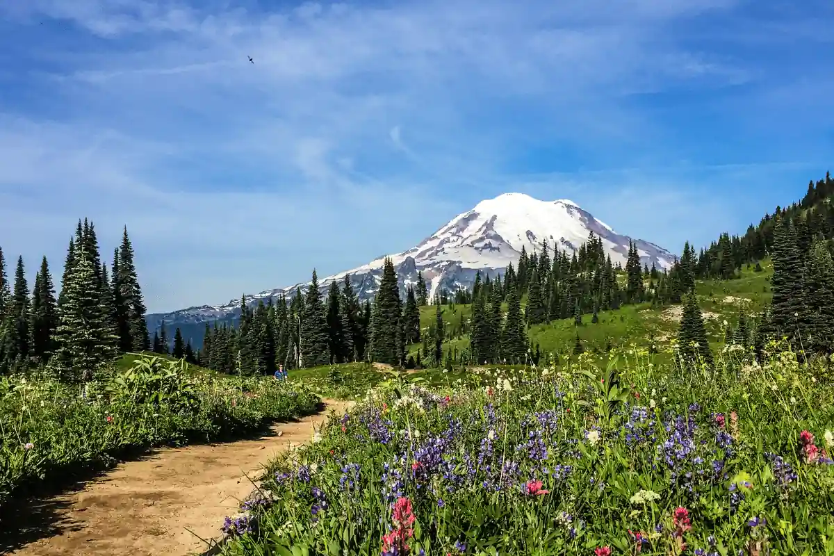
BONUS: Circle Mt. Rainier’s Base on the Wonderland Trail
One of my personal bucket list items, growing up in the shadow of Mt Rainier this trail has become one of the trails I wish I had done before I left the state, now I plan to get a permit and head back!
For those that don’t know the Wonderland Trail encircles the base of Mt Rainier and it has some spectacular views, but being Washington state it also means a high likelihood of near-constant rain.
To complete a thru-hike in a long continuous loop will typically take anywhere between four days for those who are experienced hikers with good conditioning to other less experienced hikers up to 10-14 days.
The average altitude gain and loss comes in about 3500 feet daily making this far more strenuous than at first glance.
As I stated above there is a requirement of a permit to have access to thru-hike this trail, check it out here on their website.
Additionally, to be mostly snow-free you want to look at hiking from late July into early September.
The trail is open year-round. It can be hiked in either direction, but most people hike it from east to west (clockwise).
It’s not a loop and ends at the Pacific Crest Trail near Chinook Pass on Highway 123 about 36 miles southeast of Tacoma or 27-mile southwest if you’re coming up I90 out towards Stevens Canyon Road exit off Interstate 90 which will take me back down into Eatonville.
BONUS: Rugged Beauty on Arkansas’ Ouachita Trail
The Ouachita Trail is 192 miles long and spans the entire Forest from Oklahoma to Arkansas. The trail starts off at Talimena State Park on Highway 271 near Talihina, Oklahoma, and then winds along Arkansas to the Perryville exit of Highway 9.
It is blazed with blue paint and maintained by the Ouachita Trail Association.
This trail is managed by the Ouachita Trail Association which is a volunteer-driven organization that maintains it and has been for more than 20 years now!
They do an amazing job of maintaining this trail so please be sure to thank them when you see one out on these trails!!
The OT follows along some very scenic ridges with views in all directions but also travels through deep forested valleys where there are no vistas at times.
This makes hiking more enjoyable because you won’t always know the next view.
You’ll find some great views along here too like the Black Rock Mountain Range. The OT is a very diverse trail with many different landscapes and environments to experience.
The terrain can be quite rugged at times too, so make sure you choose the right backpacking gear, but also has some of the most beautiful views I’ve ever seen in my life!
It’s so nice having such amazing diversity here on this one single long-distance thru-hike because it means that you never get bored hiking these miles.
Leave a Comment